

Engineering Surveying GNSS RTK GPS/Land Manage RTK GPS
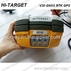
The V30 GNSS RTK GPS system is designed to meet high quality standards at an affordable price. It is outstanding in it's class, with a rugged design and user-friendly functions.

Technical Parameter of the GNSS RTK GPS:
| Performance Specification | ||
| Measurements | Advanced PCC Maxwell 6 custom survey chip with 220 channels | |
| High Precision Multiple Correlator for GNSS Pseudorange measurement. | ||
| Very low nolse GNSS carrier phase measurements with <1mm precision in | ||
| 1Hz, proven low elevation tracking technology. | ||
| Signal of noise rations reported in DB-Hz. | ||
| Satellite Singnals | Signal trackingGPS: L1 C/A, L2E, L2C, L5 | |
| Tracked | GLONASS: L1 C/A, L1 P, L2 C/A | |
| Simultaneously | (restricted to GLONASS M) and L2 P | |
| GALILEO:upgrade | ||
| SBAS:WAAS,MSAS,EGNOS | ||
| Accuracy | Static Fast Staic GNSS Surveying | Horizontal: ±(2.5+1×10⁻⁶D)mm |
| Vertical: ±(5+1×10⁻⁶D)mm | ||
| WAAS Differential Surveying | Typically < 3meter | |
| Stop and GO Surveying | Horizontal: ±(625px+1×10⁻⁶D)mm | |
| Vertical: ±(50+1×10⁻⁶D)mm | ||
Intiallization Time: typically 10 minutes for base while 5min for rover | ||
| Intiallization Reliablibity >99.9% | ||
| RTK Surveying | orizontal: ±(10+1×10⁻⁶D)mm | |
| Vertical: ±(20+1×10⁻⁶D)mm | ||
| Hardware | Physical | Storage: 64M |
| Operating system: Windows CE 5.0 or Windows | ||
| Mobile 6.1 , | ||
| CPU: 533MHz high-speed ARM920T processor , | ||
Memory: 128MB SDRAM Built-in 512M flash drive, and flash drives, over 1 G supported | ||
Display: 3.5 inches NEC professional outdoor touched color screen | ||
| Dimension: 19.5 cm X 10.4 cm | ||
| Weight: 1300g (Incl. Lithium battery) | ||
Environmental characteristicsTwo meters water-proof, anti-3m natural drop completely dust-proof, IP67 grade | ||
| Operating temperature: -45℃~65℃ | ||
| Storage:temperature: -55℃~85℃ | ||
| Electrical | Main unit power: 2.5W | |
| Power input: 6-36 V DC | ||
Battery system: Internal dual compartment Lithium battery system, each battery capability 4400mAh working up to 10 hours for GPRS mobile | ||
| Communication & Data Storage | DATA Memory | 64M |
| UHF radio Communication | Compatible with V8, HD6000 and other proudcts which radi oin 460Mhz, with differential transmit-receive functions and transmit pwoer adjutable among 0.1w 1w and 2w. | |
The frequency range of radio is 455Mhz - 465Mhz or 440Mhz - 450 Mhz, with 100 flexible switching channels. | ||
| External radio with top 19.2Kbps wireless transmit speed. | ||
| PCC Internal radio (optional) | Compatible with Trimble and Leica | |
| With differential transmit-receiver functions | ||
| and transmit power adjutsable among 0.1w, 0.5w, 1w. | ||
| The Frequency range of radio is 430mhz - 470Mhz, | ||
| with 32 flexible switching channels, | ||
| the frequency list can be customized. | ||
| With top 19.2kBps wireless transmit speed. | ||
| The Radio supports below protocol: | ||
| Transparent EOT Timeout/Transparent EOC | ||
| character / Packet Switched /TRIMTALK | ||
| 450S/TRIMMARK ii/LLE/TRIMTALK3/TT450S/STEL | ||
| External PCC Radio (Optional) | Input power: DC 9-30V | |
| With Transmit-receive function, transmit pwoer | ||
| adjustable and the top transmit power optional | ||
| between 4W and 35W. | ||
| The frequency range of radio is 430-470 MHz, with | ||
| 32 flexible switching channels, the frequency list | ||
| can be customized. | ||
| With top 19.2 Kbps wireless | ||
Data formats
(1Hz positioning output, up to 50 Hz - depends on installed option)
CMR: sCMRx, CMR, CMR+input and output
RTCM: RTCM 2.1, 2.2, 2.3, 3.0, 3.1 input and output
Navigation outputs ASCII: NMEA-0183 GSV, AVR, RMC, HDT, VGK, VHD, ROT, GGK, GGA, GSA, ZDA, VTG, GST, PJT, PJK, BPQ, GLL, GRS, GBS
Navigation outputs Binary: GSOF
1 Pulse Per Second Output
Main Application of the V30 GNSS RTK GPS:
Construction stakeout
Rich point, line stakeout functions, combined with graphical user guidance to help you save more construction cost
Traffic Power
Convenient power direction finding, ranging, angle calculation function; comprehensive and practical road layout, the pile, pile edge measurement, vertical, cross-sectional measurements
CORS Application
CORS system for applications, just need one rover station can receive CORS RTK differential signal to do data collection, construction layout, etc.
CORS station
HD-CORS combines the advantages of HI-TARGET, such as mature technology, stable running, long distance transmission, etc., it is the solution of choice for a city to build a continuous reference station.
Control Survey
An investment, multiple functions, V30 GNSS RTK dual frequency static measurement accuracy meets the requirements of any control measure, supporting mature professional data solver software that can help you complete a variety of high-precision control measurements
Data collection
GIS-oriented system design hand book operating software, flexible encoding capabilities to meet your fast and efficient needs in data collection in the wild
Above Water Measurement
Work with HI-TARGET marine surveying, mapping software and echo sounder, easy to finish underwater topography measure, completely change the traditional mode of above water measurement and operation
Underwater Construction Positioning
With HI-TARGET marine construction positioning software, V30 GNSS RTK system could help you accurately complete riprap, arrangement, piling and other marine engineering, to meet the special requirements for marine engineering construction projects.
Main Features of the HI-TARGET V30 GNSS RTK GPS:
Multi-constellation tracking
220 tracking channels.
Supports GPS, GLONASS, GALILEO, BDS, SBAS.
NGS approved GNSS antenna.
Intelligent operation
Equipped with a smart speaker guiding the whole operation.
Multi one-button functions make fieldwork easier, such as auto base setup by one button, the rover can get fix solution once it is turned on.
Diversify RTK application
Optional transceiver UHF radio
The transceiver UHF radio enables the working mode to be switchable between base and rover.
2-watt HI-TARGET internal UHF radio and 2-watt Pacific Crest TrimTalk© internal UHF radio are optional. Pacific Crest TrimTalk© internal UHF radio is compatible with other radios.
Removable internal UHF radio enables users to fix or exchange simply.
Seamless operation in CORS system
Built-in GPRS/GSM/3G module ensures that the V30 works perfectly with network RTK positioning.
Long-life battery
Powered by 5000mAh Li-ion battery.
Static working time 13 - 15 hours.
RTK Rover (UHF/GPRS/GSM) working time 10 - 12 hours.
RTK Base working time 8 - 10 hours.
Rugged and unique design
IP67 dust/water protection.
Withstands 3-meter natural fall onto concrete.
Rapid tracking and perfect avoidance or reduction of obstruction and multipath effect to ensure superior positioning capability.
Contact US:


